What is XMP Data?
360 images have hidden text embedded into the image data. This data is called metadata. It is not designed for humans. A computer reads in the metadata.
Photo Sphere XMP Metadata is a Google standard taken from the Adobe XMP standard. You can edit this data with an image editor or a text editor. Most 360 image viewers such as Facebook will support XMP data. As 360 images are still new, not all applications support XMP data. If the application does not support XMP data, you will need to edit the entire image with something link Hugin or Photoshop.
Why Use XMP Data?
Editing the XMP data uses less CPU and memory resources. Your application can change the text string for orientation with almost no delay for the user of your application. Editing the entire image orientation with image editing techniques is going to place a heavy load on the mobile or desktop application.
What Can You Edit?
You can edit both the XMP data embedded in the THETA image as well as add new XMP data tags that comply to the Photo Sphere XMP Metadata standard. For example, your application can add GPS data as well as initial view data to the image. The data can then be used by 360 viewing applications such as Facebook.
Overview of Functionality using Facebook as Viewer
This is the same image shown on Facebook with no mouse editing. The orientation was changed by only using XMP data strings.
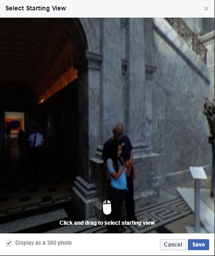
Default View of Image Before Editing
The original image looks like this on Facebook with no editing. Although Facebook allows you to set the orientation with their Facebook app, let’s imagine that you’re building a better Facebook or building a new application to support XMP data. Imagine that the mouse is not there.
This is the default XMP data that we’ll edit for our tests.
  <GPano:PosePitchDegrees>-0.9</GPano:PosePitchDegrees>
  <GPano:PoseRollDegrees>-0.4</GPano:PoseRollDegrees>
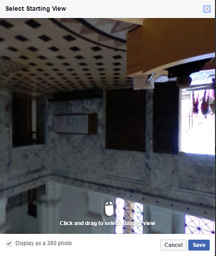
Pose Pitch Increased by 180 Degrees
Here, I’ll increase the PosePitchDegrees by 180 degrees to illustrate the orientation change. Image the camera is upside and you need to correct the image orientation.
  <GPano:PosePitchDegrees>179.1</GPano:PosePitchDegrees>
  <GPano:PoseRollDegrees>-0.4</GPano:PoseRollDegrees>
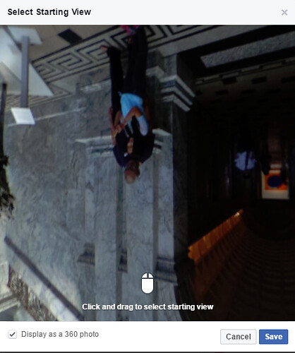
Pose Roll Increased by 180 Degrees
In the next example, I’ve increased the Roll by 180 and reset the Pitch to the default value.
  <GPano:PosePitchDegrees>-0.9</GPano:PosePitchDegrees>
  <GPano:PoseRollDegrees>179.6</GPano:PoseRollDegrees>
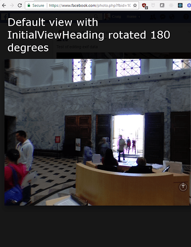
InitialViewHeadingDegrees Decreased by 180
In the next example, I’ve added a new metadata tag for InitialViewHeadingDegrees. I got the name of the tag from the XMP standard. I’ve rotated the orientation by 180 degrees to show the back of the image sphere.
  <GPano:PosePitchDegrees>-0.9</GPano:PosePitchDegrees>
  <GPano:PoseRollDegrees>-0.4</GPano:PoseRollDegrees>
  <GPano:InitialViewHeadingDegrees>135</GPano:InitialViewHeadingDegrees>
Editing XMP Data
You can either use a GUI tool or adjust the metadata from the command line. Most people will probably test the XMP editing with the GUI tool, then write a script to adjust the XMP data. Two common tools are:
- ExifTool by Phil Harvey
- ExifToolGUI
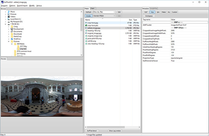
ExifToolGUI
Use the file browser on the left to open the THETA image.
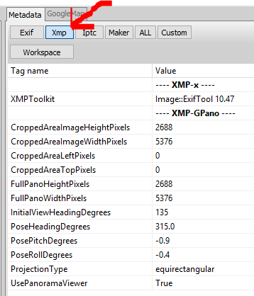
The pane on the right shows the Xmp data.
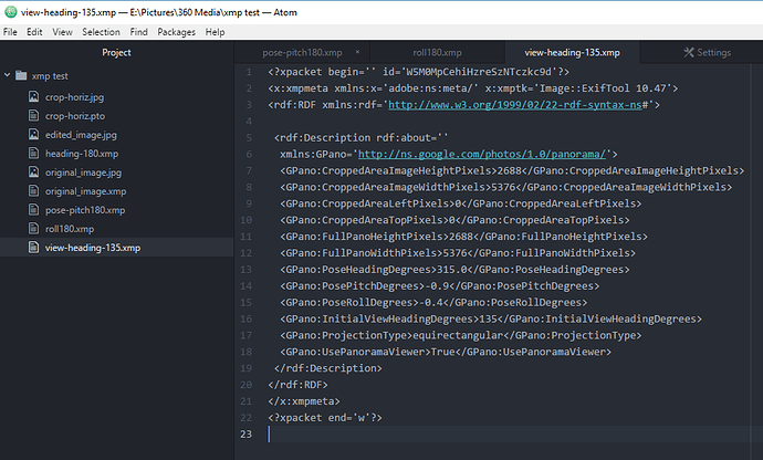
Export XMP Data to Text File
Edit XMP File in Text Editor
Import XMP Data Into Image
With image you want to edit selected, copy metadata from single file.
Exiftool
You can read and edit the XMP data directly from the command line. In the examples below, I’m using a bash shell on Windows.
Reading Data
$ ./exiftool.exe edited_image.jpg > data.txt
$ less data.txt

ExifTool Version Number         : 10.47
File Name                       : edited_image.jpg
Directory                       : .
File Size                       : 3.7 MB
File Modification Date/Time     : 2017:05:31 12:44:39-07:00
File Access Date/Time           : 2017:05:31 12:44:39-07:00
File Creation Date/Time         : 2017:05:31 11:31:21-07:00
File Permissions                : rw-rw-rw-
File Type                       : JPEG
File Type Extension             : jpg
MIME Type                       : image/jpeg
Exif Byte Order                 : Big-endian (Motorola, MM)
Image Description               :
Make                            : RICOH
Camera Model Name               : RICOH THETA S
Orientation                     : Horizontal (normal)
X Resolution                    : 72
Y Resolution                    : 72
Resolution Unit                 : inches
Software                        : RICOH THETA S Ver 1.62
Modify Date                     : 2016:10:23 12:25:33
Y Cb Cr Positioning             : Co-sited
Copyright                       :
Exposure Time                   : 1/125
F Number                        : 2.0
ISO                             : 100
Sensitivity Type                : Standard Output Sensitivity
Exif Version                    : 0230
Date/Time Original              : 2016:10:23 12:25:33
Create Date                     : 2016:10:23 12:25:33
Components Configuration        : Y, Cb, Cr, -
Compressed Bits Per Pixel       : 3.2
Aperture Value                  : 2.0
Brightness Value                : 3.5
Exposure Compensation           : -0.7
Max Aperture Value              : 2.0
Metering Mode                   : Multi-segment
Light Source                    : Unknown
Flash                           : No Flash
Focal Length                    : 1.3 mm
Maker Note Type                 : Rdc
Firmware Version                : 1.62
Serial Number                   : (00000000)00010093
Recording Format                : JPEG
Accelerometer                   : 359.6 -0.9
Compass                         : 315
Time Zone                       : -07:00
Exposure Program                : Auto
White Balance                   : Auto
User Comment                    :
Flashpix Version                : 0100
Color Space                     : sRGB
Exif Image Width                : 5376
Exif Image Height               : 2688
Interoperability Index          : R98 - DCF basic file (sRGB)
Interoperability Version        : 0100
Exposure Mode                   : Auto
Scene Capture Type              : Standard
Sharpness                       : Normal
GPS Version ID                  : 2.3.0.0
GPS Latitude Ref                : North
GPS Longitude Ref               : West
GPS Altitude Ref                : Above Sea Level
GPS Time Stamp                  : 19:25:31
GPS Img Direction Ref           : True North
GPS Img Direction               : 315
GPS Map Datum                   : WGS84
GPS Date Stamp                  : 2016:10:23
Compression                     : JPEG (old-style)
Thumbnail Offset                : 58496
Thumbnail Length                : 3118
XMP Toolkit                     : Image::ExifTool 10.47
Cropped Area Image Height Pixels: 2688
Cropped Area Image Width Pixels : 5376
Cropped Area Left Pixels        : 0
Cropped Area Top Pixels         : 0
Full Pano Height Pixels         : 2688
Full Pano Width Pixels          : 5376
Initial View Heading Degrees    : 135
Pose Heading Degrees            : 315.0
Pose Pitch Degrees              : -0.9
Pose Roll Degrees               : -0.4
Projection Type                 : equirectangular
Use Panorama Viewer             : True
Image Width                     : 5376
Image Height                    : 2688
Encoding Process                : Baseline DCT, Huffman coding
Bits Per Sample                 : 8
Color Components                : 3
Y Cb Cr Sub Sampling            : YCbCr4:2:2 (2 1)
Aperture                        : 2.0
GPS Altitude                    : 36 m Above Sea Level
GPS Date/Time                   : 2016:10:23 19:25:31Z
GPS Latitude                    : 37 deg 25' 58.58" N
GPS Longitude                   : 122 deg 10' 14.32" W
GPS Position                    : 37 deg 25' 58.58" N, 122 deg 10' 14.32" W
Image Size                      : 5376x2688
Megapixels                      : 14.5
Ricoh Pitch                     : -0.9
Ricoh Roll                      : -0.399999999999977
Shutter Speed                   : 1/125
Thumbnail Image                 : (Binary data 3118 bytes, use -b option to extract)
Focal Length                    : 1.3 mm
Light Value                     : 9.0
Writing Data
$ ./exiftool.exe -InitialViewHeadingDegrees=45 edited_image.jpg
    1 image files updated
Related Articles
Metadata Technique
- THETA S Auto-level bash script by Koen Hufkens
- Getting 360 Images to Work After Resize: EXIF technique
- Process horizon correction for THETA - dozens of files at a time
