After a couple of hours messing with various settings my Theta X is now configured to use A-GPS via an Android phone hotspot. Whilst this will hopefully give quicker positions from a cold start, and perhaps positions where GNSS alone may not work due to satellite geometry, I do not anticipate that this will result in more accurate positions. I see that the GNSS chip receives SBAS signals which would improve accuracy. Has anyone asked Ricoh this question and/otr looked into whether this signal can be used in the Theta X (or upcoming models ?
1 Like
How can you tell that the chip receives SBAS? If it is more accurate, why wouldn’t all phone use SBAS? There must be some downside, right?
It’s likely that this type of device could work with the THETA X as the THETA Z1 is listed as a compatible camera.
You could try send them an email and confirm if the THETA X is compatible.
The spec. sheet of the Ublox chipset and the Ricoh documentation indicates that it is SBAS capable. SBAS is a worldwide service primarily used in transportation tracking, approx. 3m accuracy as opposed to approx, 5m for GNSS, and is delivered in regional flavours, such as EGNOS in Europe, (where a signup is required). For Ricoh to integrate this into their software may not be a worthwhile ROI for them, which I fully understand.
I have considered REDCATCH and it is a very good solution at a great price. I am using my Theta X on outdoor projects with CupixVista and I am looking to see whether using the A-GPS or SBAS improves the results I am getting.
2 Likes
I’ll submit community feedback in a general report. Are you referring to this documentation?
Reach the full potential of RICOH THETA X with built-in GPS l RICOH360 Blog
In addition to support for GLONASS and MICHIBIKI (QZSS), THETA X also supports A-GPS (Assisted GPS), increasing its potential for highly accurate location information.
Indoors and in other environments where the built-in GPS might not acquire location information it is still possible to add location information by connecting to the smartphone app via wireless LAN or Bluetooth just as with previous THETA models, which required a smartphone to get the location information.
GPS Specifications:
GPS, GLONASS, QZSS, SBAS(WAAS, EGNOS, MSAS, GAGAN), A-GPS
Are you looking for button on the menu that enables SBAS?
Note that I’m not familiar with the terminology. I don’t quite understand the difference between A-GPS and SBAS. Is it that A-GPS uses WiFi to download some additional information to improve the accuracy and SBAS uses satellite?
A-GPS is an internet based resource that in part speeds up the GNSS (GPS) initialisation process by providing an upto date ephemeris (listing of current and predicted satellite locations). A-GPS does not improve accuracy but is very helpful in obtainining and maintaining reliable GNSS locations.
SBAS on the other hand is a differential Correction Service that improves the accuracy of the GNSS derived location. So the answer to your question is Yes, I am looking for a button on the menu that enables SBAS which is a satellite based service
1 Like
It might be more effective if you sent Cupix an email and asked them to inquire with RICOH if the SBAS can be added as an option to the THETA X.
A clear use case or demand would help gather support.
BTW, I installed this software inside of the THETA X.
SBAS does not appear to be available in my area.
If your THETA X is in developer mode, you could install the same or similar software and check if the SBAS data is being read by the app.
Hi Craig, thanks for the suggestion, i will follow it up. The SBAS satellites are geo-stationary staellites ie. they stay in the same place wrt. the ground and they are simply communication satellites transmitting GNSS corrections from networks of ground stations, they do not transmit their own location and do not show up in the GNSS constellation.
1 Like
@Kevin_Hainsworth thanks for your help in explaining this. Just to be clear, I will include this in a report on community feedback. However, it would carry even more weight if a software partner like Cupix also made the request.
1 Like
My thoughts on frame rate, GNSS and movement type in my Facebook post of 20230723 Ricoh THETA 360° Camera User Group | # Theta X for mapping | Facebook
I feel there is a lot to improve in the useability of the X for Google Street View and Mapillary capture.
From your post
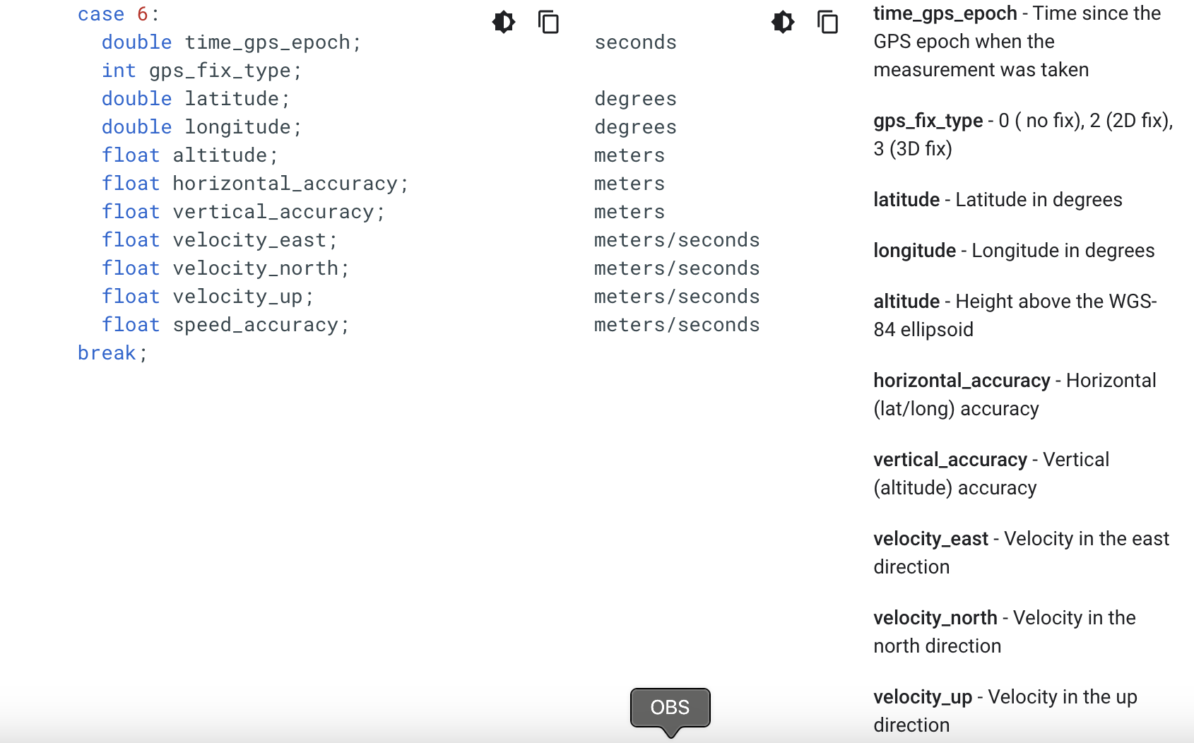
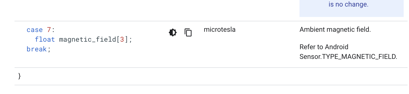
I think it may be useful to write a case 6 type GPS information data packet instead of the case 5 type and add a case 7 type with the compass data.
For the camm-spec
What values are needed to improve the accuracy? How is the horizontal_accuracy and vertical_accuracy calculated?
For case 7, are you saying that the compass data is not in the CAMM data in the video file?
@JoscTr you may want to repost the important points in this forum. I don’t think some of the RICOH engineers have access to Facebook. We include links to this forum in the report as this forum does not require login to read the posts.
@Kevin_Hainsworth , I received information from RICOH on SBAS. It is enabled by default.
“The RICOH THETA X built-in GPS has SBAS enabled by default. There is no way for customers to check exactly whether SBAS augmentation data is enabled, but if the position accuracy is around 3m in open sky (the sky is visible in all directions with no obstructions at an elevation angle of 30 degrees or more), then it is considered to be enabled. If it is enabled it, the position accuracy would be around 3m. If it is disabled, it would be around 10m.”
1 Like
That is good to hear. Thanks for taking the time to look into this. Here is a Linkedin post showing how I am using the theta X with CupixVista software Ricoh Theta X and CupixVista
They have some good ideas.
3 Likes
Is it okay if I repost some of that information here in this topic so that I can show the team at RICOH the use case? I’m not sure if they use LinkedIn.
1 Like
@craig
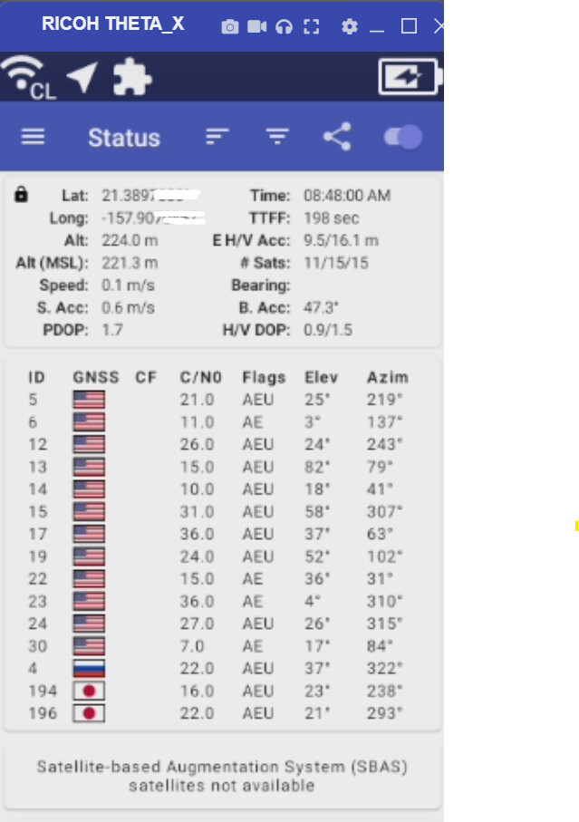
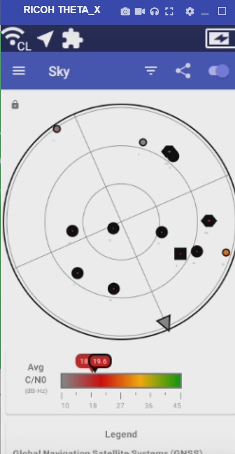
From your images, it is confirmed that the X’s capability in position determination is not tuned to its best. What shows in the image is the reception of the USA GPS, the Russian Glonass and the Japanese systems, the European Galileo, China’s Beidou and general SBAS enhancement are missing. As per the specs (uBlox ZOE-M8B) of the X’s GNSS component manufacturer, these are supported. I would really appreciate the Theta team looking into improved use of the GNSS hardware. I’d love to get my X out of the drawer for mapping. I am keen on Galileo support as it is said to be more precise. The hardware supports 3 out of the 4 + SBAS enhencement at the same time.
On GNSS: Satellite navigation - Wikipedia
Would these satellites be available anywhere in the world? If it’s supported by the GPS chip, why wouldn’t RICOH have implemented it from the beginning? Is there some type of licensing cost? Or, is it technology implementation?
I have an Android Google Pixel 4a. I can try compare the GPS satellite detection of my Google Pixel 4a versus the THETA X and post the pictures here.
Would that be a fair comparison?
Update May 14, 2024
I was looking at the camera spec and I can’t find mention of supporting European Galileo and Beidou.
Maybe a software vendor needs to request this support for a specific application?
These were the specifications listed.
GPS, GLONASS, QZSS, SBAS(WAAS, EGNOS, MSAS, GAGAN), A-GPS
2 Likes
Hi Craig, sorry for having such delay in responding. It is not you to blame, but I am a bit fed-up with the poor implementation by camera manafacturers of positioning hardware capabilities. Not to mention that they should use hardware that provides for fusion with dead reckoning too.
- It is not a GPS chip, it is a GNSS chip. GPS is only one of the GNSS’. Refer Wikipedia.
- There is no separate licensing cost.
- It is a matter of software implementation on device with appropriate settings. Higher sampling frequency and using more networks may go at the expense of more power consumption. But, using X for mapping it will be on powerbank instead of internal battery.
- Yes, the other satellite networks cover all of the globe too.
- A Pixel 4a is a bit historic, it may not have support all networks, but likely not the new frequencies.
- What the camera spec says is not relevant. The uBlox ZOE-M8 is the hardware concerned that detemines the potential of position quality.
- No, it is up to Ricoh to implement all functionality and option settings in the camera software.
From a Giroptic, to Theta V, to Pilot Era, to Pilot One to Theta X. Lots of promises always for continued software improvement, but poor delivery. In the end, mapping for Google Street View, Mapillary and the like is a niche.
But, thanks for your attention Craig.
2 Likes
thank you for contributing your knowledge to the forum.
I believe that only viable solution to get higher accuracy is to use something like RedCatch GNSS-RTK add-on.
Where did you find that the THETA X uses the uBlox ZOE-M8B?
I searched on this blog and the spec sheet for the THETA X, but could not find reference to the GNSS chip used.
Reference
more detailed post by JoscTr on this subject.
Sure @craig , RTK support is top notch, but requires subscription to such service, if I remember well. My plea is that a lot can be improved without that.
I don’t know from which article at the time I got the info that X uses uBlox ZOE-M8B. But, now searching Bing and Google with “Ricoh theta x uBlox” surfaces several articles, including a uBlox press announcement.
Indeed, spec details by camera manufacturers are poor. When buying a phone or some other sort of pc, more hardware details are available in spec sheets.
thank you again for your help. I’m working with @jcasman to summary the information you posted in the other topic.
1 Like