As mentioned in Options to display 360 images on a public map I came across issues whilst trying to publish 360 photos to Google Maps. I hinted that I might write a little tool.
Well first cut is done - I’m not sure if this is of interest to just me or if its of more general interest … I figured it was worth sharing anyway. See see GitHub - plord12/360tools: Tools to help publish 360 images .
I plan to iterate on more feature as and when I need them.
I built binaries for a few platforms, but note that I can only test on Mac (M1) so there may well be issues on other platforms.
Comments / ideas etc more than welcome of course.
Pete
2 Likes
craig
March 23, 2023, 4:26pm
2
@Peter_Lord
We’ve awarded you a Community Thanks Award for this solution.
In addition to the awesome badge, we’d like to buy a you beer. We’ll send a small cash award using the Donate link on your 360 tools GitHub repo . If you don’t drink alcohol please buy yourself lunch or electronic parts for a fun project.
Golly, that was unexpected. Thanks very much … off to the pub now
2 Likes
craig
March 23, 2023, 4:59pm
4
I was surprised that you were able to put together a project so quickly. Thanks for sharing it as open source. Have fun.
1 Like
Just pushed v0.0.2 which includes -
Adds support for GPX tracks to obtain photo locations
Adds support to generate uMap files
Also added some screenshots (uMap is worth a look if you arn’t familiar with it).
I did consider adding mapillary, but I see it already has a tool ( GitHub - mapillary/mapillary_tools: Command line tools for processing and uploading Mapillary imagery ).
3 Likes
craig
March 27, 2023, 4:37pm
6
Nice update!
@jcasman , when @erikrod1 finishes his react native document, ask him to test and provide additional community documentation in this topic.
I suggest that he focus most of his time on Google Maps, but also look at uMap
What is Mapillary? Is it a commercial company or an open source project?
2 Likes
Yes, planning on it! I’m interested in testing @Peter_Lord 's project, it fixes and known problem and looks pretty cool.
Street level imagary - Mapillary - now owned by Facebook
2 Likes
Hey Peter, I’m going to be trying out your 360 Image Publishing CLI tool and the location problems that it solves! Will report back with results.
2 Likes
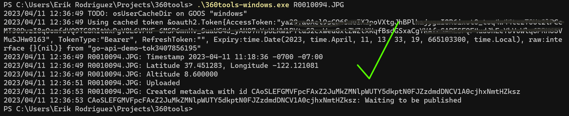
Tool worked great once I troubleshooted some things to set it up on my end.
Looks like it ran with no issues on Windows. Also waiting for my photo to be published…
1 Like
craig
April 11, 2023, 8:25pm
11
Do you need to obscure your API token information in the image? Just to be safe, I edited your image to obscure the token. I’m not sure if people can abuse your API credentials with the token or not.
Great ! Thanks for “testing” on windows.
2 Likes
I’ll remove from the code anyways ( I think that was from the Google example code ! )
2 Likes