The location accuracy of GPS chips of most mobile phones and also the THETA X chip vary based on satellite location and other factors. The US government official site indicates that mobile phones can provide 5m accuracy under an open sky. As a rough guide, the THETA X can be grouped with the accuracy of mobile phone.There are two strategies to store higher accuracy:
- use an external GPS with higher accuracy and store it in a separate log file. Match the GPS timestamp with the timestamp of the THETA images or video frames (in CaMM data in certain formats).
- store GPS information in the image metadata of each image.
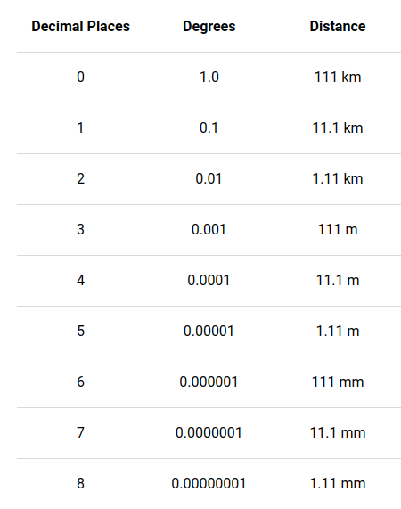
GPS location stored in the image metadata is in the Exif IFD format, which has the following accuracy: Lat/Lng dd/1 mm/1 ss/100. This is roughly equivalent to 30cm.
Understanding GPS Numbers
accuracy information: source
Add GPS Information To Image Metadata
In typical use, a mobile phone GPS sends location information to the Z1 and interfaces with the camera using an API to save the GPS information
Note that mobile phone GPS units are accurate to approximately 5m. Even if there is greater apparent accuracy stored in the image metadata using the API, the actual accuracy is limited to the GPS unit, meaning that the input data from the mobile phone or onboard GPS could be less accurate than the numbers stored in the metadata.
Video
If you want GPS and sensor data to be matched with the frames of a video, you need to extract the CaMM data track, just just the standard exif data used in the image example above.
CaMM Data in Videos
Official THETA Metadata Specification
THETA X stores IMU data in CaMM format
Community example of extracting data
Note that the example on the right was produced with a Z1 using a special two fisheye video format specified here